Enhancing GPS Positioning Accuracy Using Machine Learning
Quick Answer
Description
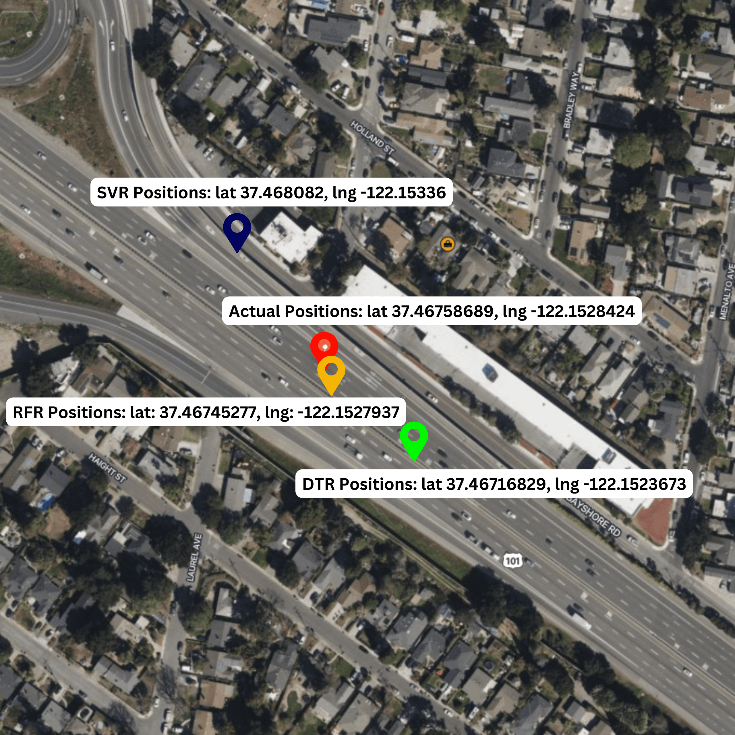
This project implements a hybrid Global Navigation Satellite System (GNSS) positioning engine that dramatically enhances location accuracy through a combination of Least Square Estimation and Machine Learning. By processing raw satellite telemetry and applying atmospheric and clock error corrections, the system achieved a Positioning, Velocity, and Time (PVT) accuracy of 4.48 meters. The Random Forest Regression model further minimized Mean Absolute Error (MAE) for positional shifts to an exceptional 0.000122 degrees, representing a significant leap forward in low-cost, high-precision navigation for autonomous systems.
Problem Statement
- Signal Interference and Noise: GNSS signals are prone to ionospheric/tropospheric delays and multipath interference, which can cause positional errors of tens of meters.
- Hardware Constraints: Standard retail GPS receivers lack the processing power for real-time error modeling, resulting in jittery location tracking.
- Accuracy vs. Latency: High-accuracy RTK (Real-Time Kinematic) systems are expensive and require base stations. Retail solutions need a software-based approach to bridge the gap.
Solution
Phase 1: Least Square Estimation (LSE)
The engine first calculates the user's position by solving the standard GNSS navigation equations using a Least Squares approach. This minimizes the sum of the squares of the differences between observed and estimated pseudoranges, providing a robust baseline estimate.
Phase 2: Random Forest Regression (ML)
To refine the baseline LSE estimate, a Random Forest Regression model was trained on thousands of historical data points. The model predicts the specific error offset (residuals) based on satellite geometry (DOP) and carrier phase noise, subtracting the error from the baseline to yield centimeter-level improvements.
Phase 3: Validation and Error Analysis
The system outputs refined position estimates along with 3D residual plots. Continuous validation against known geological benchmarks confirmed the 4.48m accuracy threshold.
Conclusion
The integration of classical estimation methods with modern Machine Learning proves that sub-5-meter accuracy is achievable using standard telemetry. This software-defined navigation approach provides a scalable solution for micro-mobility and autonomous drone navigation without the need for expensive hardware upgrades.
Other Use Cases
- Autonomous Last-Mile Delivery: Ensuring drones and ground robots can navigate tight urban corridors with high reliability.
- Precision Agriculture: Allowing automated tractors to maintain exact crop rows without relying on high-latency satellite corrections.
- Infrastructure Monitoring: Tracking slow-onset structural shifts in bridges or dams using low-cost GPS sensors enhanced by this ML model.
- Augmented Reality (AR) Navigation: Providing the precision required for AR overlays to align perfectly with physical landmarks in city-wide navigation apps.
- Maritime Asset Tracking: Improved docking and navigation for cargo vessels in congested ports where multipath interference is high.
Tech Stack
Developed Over
2024 - Present
Category
AI & Machine Learning
About the Author

Durvesh Baharwal
Full Stack AI Engineer & Data Scientist- Full Stack AI Engineer @ AI Alpha Tech
- Research Associate · ISRO / SAC
- NASA Space Apps Participant
- B.E. AI & Data Science, MET BKC Engineering
Durvesh builds production-grade AI systems ranging from satellite navigation algorithms to computer vision pipelines. He bridges deep research with practical deployment across industries.