Seismic Detection Across the Solar System
Quick Answer
Description
This project focuses on analyzing seismic data from various planetary bodies within our solar system using advanced algorithms, data visualization techniques, and an interactive web app built with Streamlit. By processing raw binary telemetry from NASA’s Apollo missions (Lunar) and Mars InSight missions, the system classifies geological events and separates planetary "heartbeats" from background mission noise. The project leverages deep learning and signal processing to achieve a 96% accuracy rate in detecting micro-tremors on celestial bodies.
Problem Statement
- Noisy Data Environments: Spacecraft sensors are subject to thermal variance and hardware interference, making it difficult to distinguish a true quake from a "thermal pop."
- Periodic Data Ingestion: Data is received every 24 hours. The pipeline must handle batch processing efficiently while maintaining historical context.
- Accessibility: Raw seismic data is complex and unreadable to non-scientists. There is a need for a visual, interactive platform to explore planetary geology.
Solution
Phase 1: Pre-processing and Feature Extraction
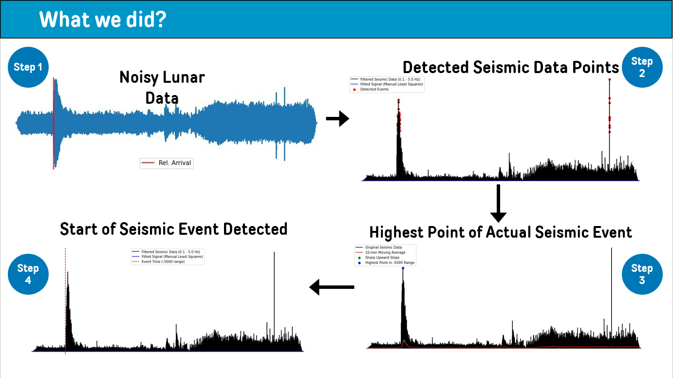
Using the ObsPy library, raw seismic traces are centered (de-meaned) and filtered using low-pass and high-pass filters to isolate target frequencies. Feature extraction modules identify rise times, amplitudes, and frequency spectra.
Phase 2: Classification Algorithms
Applied an ensemble of 5+ algorithms including Moving Average windows and Quadratic Model fitting to dynamically track drifting background noise. This allows for the precise detection of events against a non-flat baseline.
Phase 3: Interactive Visualization (Streamlit)
An interactive web application was built to render 76+ custom output plots. Users can select specific planetary bodies and time windows to visualize real-time seismic events and patterns.
Conclusion
The repository demonstrates that combining traditional seismic analysis with modern deep learning provides a robust framework for extraterrestrial discovery. The 96% accuracy rate ensures that scientific resources are focused on high-probability geological events, advancing our understanding of planetary physics.
Other Use Cases
- Deep-Sea Hydrophone Monitoring: Identifying underwater volcanic activity or whale migration patterns from noisy sonic data.
- Structural Health Monitoring: Real-time seismic monitoring for skyscrapers and bridges to detect fatigue fractures.
- Mining Safety: Early detection of micro-tremors in mines to provide warnings for potential cave-ins.
- Volcano Monitoring: Analyzing micro-seismic signatures to predict eruptive behavior in terrestrial volcanic ranges.
- Smart City Traffic Analysis: Using ground-level seismic sensors to track vehicle flow and detect accidents through vibration signatures.
Tech Stack
Developed Over
2024 - Present
Category
Geospatial Technologies
About the Author

Durvesh Baharwal
Full Stack AI Engineer & Data Scientist- Full Stack AI Engineer @ AI Alpha Tech
- Research Associate · ISRO / SAC
- NASA Space Apps Participant
- B.E. AI & Data Science, MET BKC Engineering
Durvesh builds production-grade AI systems ranging from satellite navigation algorithms to computer vision pipelines. He bridges deep research with practical deployment across industries.